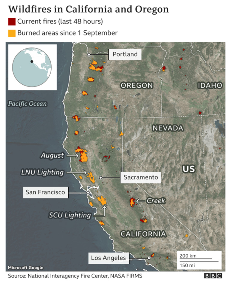
At the beginning of 2020, great concern was generated due to the images published in news, internet, and social media related to wildfires in Australia which portrayed injured and displaced animals, and thousands of acres of burning forests. Four months after the wildfire in Australia, the same scenario happened in Russia where high temperatures were reached in Siberia. These temperatures were unusual in this region as it belongs to the tundra which is the coldest of all biomes with an annual average temperature of less than 5°C. Lately, another wave of wildfires attacked nature, but this time on the west coast of the United States, affecting mainly the states of California, Oregon, and Washington.
Impacts of the uncontrolled spread of wildfires
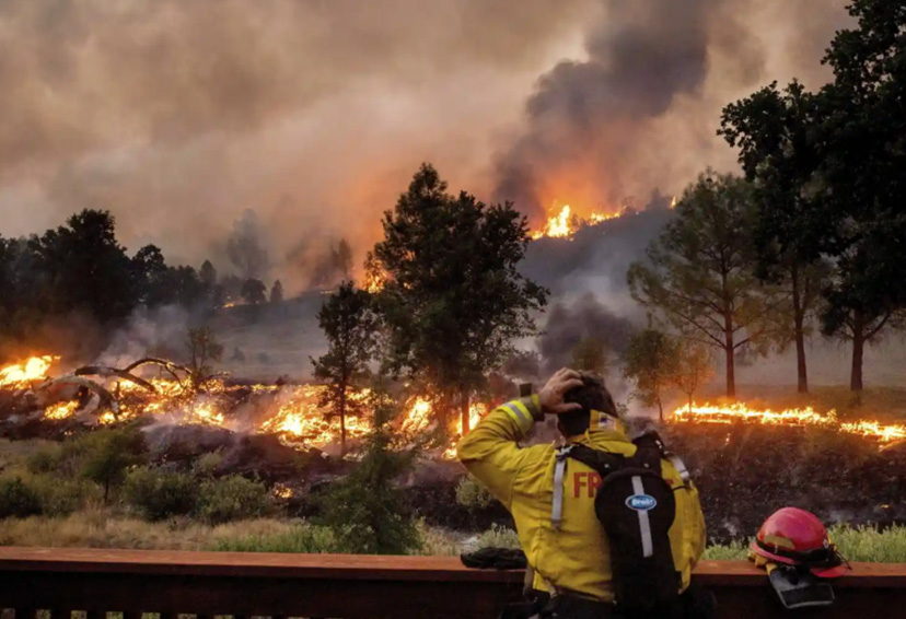
The occurrence of these large wildfires has brought great problems to the inhabitants of many locations, as strong winds have displaced the smoke produced by the burned material to a vast area. In the most affected states, the amount of smoke has been so high that pollution levels classified as dangerous to human life have been reached.
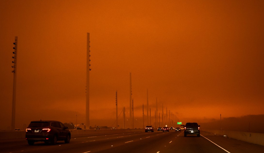
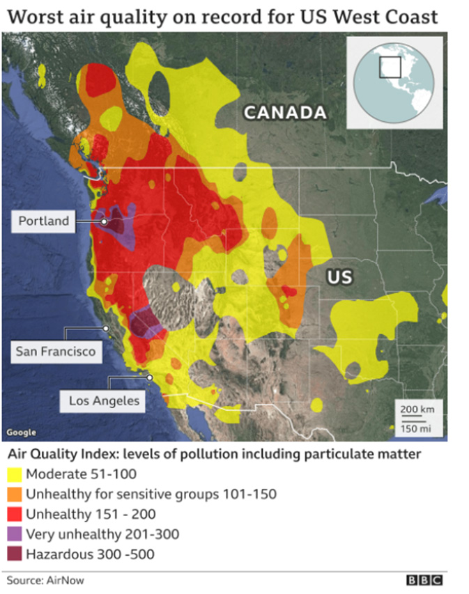
Until now, these fires have caused more than 35 deaths and numerous health problems in the population of the affected areas. The prior is explained by the fact that the residual ash particles have the ability to penetrate the lungs and do not decompose, which allows them to reach the bloodstream and vital organs causing, in some cases, irreversible health problems.
Why is global warming amplifying the effects of wildfires?
It is necessary to mention that wildfires are not new occurrences and are caused, in most cases, by natural reasons. These fires take place where there is a favorable climate (dry vegetation along with lightings) and enough fuel to keep the flames (dry leaves, wood, dead trees, etc). However, the wildfires of 2020 (Australia, Siberia, and the west coast of the United States) have shown various similarities that did not occur in previous events. First, the flames started earlier than expected. Second, the extent of the flames increased by almost double compared to past seasons. Lastly, and most worrying of all, their duration was much longer compared to previous events; approximately 78 days for each of them.
As it is well known, climate change is generating extreme conditions of climatic phenomena, such as precipitation, temperature, and cloud cover, among others. This can be evidenced in the rising temperature of the earth that results, among other things, in the acceleration of the evaporation process of water particles present in vegetation and the soil. The prior creates the ideal conditions for the generation of forest fires, and explains the increase in their duration, extension, and in the consequent social impacts. The effects that we as human beings are observing make clear the need to invest in forest management programs aimed at reducing the frequency of occurrence and intensity of fires and mitigating the risk once they happen to occur.
References
https://www.bbc.com/news/world-us-canada-54180049
https://www.bbc.com/news/science-environment-54278988
https://www.theguardian.com/us-news/2020/oct/05/california-fires-4m-acres-wildfires-burn
https://www.theguardian.com/us-news/2020/oct/06/california-wildfires-gigafire-first
▪ ▪ ▪
Related content:
“What causes a wildfire? | Natural Disaster” fromIn this video we examine how wildfires are formed. In order for a wildfire to spread, certain conditions must occur over a significant number of years beforehand – these include a temperate climate to allow the growth of rich vegetation, a prolonged period of strong dry heat and a spark to ignite the flame. |